Drone App: Forecast for UAV

1M+
Installs
Go Dreams
Developer
-
Finance
Category
-
Everyone
Content Rating
-
https://gardenofdreams.games/privacy-policy-3
Privacy Policy
Screenshots
editor reviews
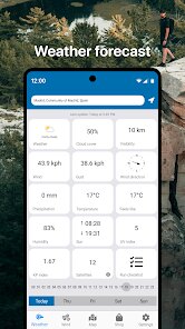
Drone pilots know the struggle - you check three weather apps before heading out, only to have a surprise gust of wind send your UAV wobbling. Forecast for UAV solves this specific headache. It's built exclusively for drone operators who need hyperlocal, aviation-grade weather data rather than the generic forecasts everyone else uses. The app pulls from over 200,000 weather stations globally and combines it with GPS positioning to give you conditions right where you're flying, not just at the nearest airport or city center.
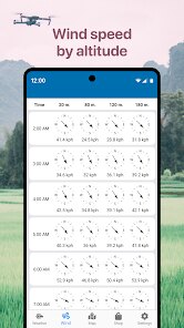
The core functionality centers on flight-suitability scoring. You drop a pin on your planned flying spot, and the app calculates a flight readiness score based on wind speed, gusts, precipitation, visibility, and K-index (which affects GPS signal quality). What makes this genuinely useful is the altitude-specific wind forecasts. A 10 mph breeze at ground level might mean 30 mph gusts at 200 feet - information most weather apps won't tell you. I've personally used this to avoid packing up my gear for a shoot that looked fine on the surface but would've been dangerous at altitude.
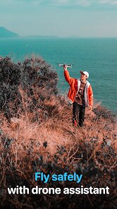
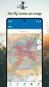
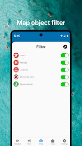
The additional features round out the experience well. You can save favorite flying locations, get push notifications when conditions change, and view hourly forecasts extending three days out. There's also a map overlay showing no-fly zones and restricted airspace, which saves you from cross-referencing a separate app for legal compliance. The only gap I've noticed is the lack of a radar loop feature for tracking incoming storms visually. I'd recommend this app to anyone flying commercially or for hobby - especially if you've ever had to chase a runaway drone or cancel a paid shoot due to unexpected weather changes.
features
- ️ The flight-readiness score is the standout feature. Instead of drowning you in raw numbers, it translates complex weather data into a simple 0-100 rating with color coding. Green means good to fly, yellow means caution, red means keep your drone on the ground. This removes the guesswork entirely and lets you make decisions in seconds rather than studying wind charts.
- ️ Altitude-specific wind forecasting addresses a real blind spot in drone operations. You toggle between 0, 50, 100, and 200 feet to see wind speed and direction at each level. This matters because conditions that feel calm on the ground can become hazardous once your drone climbs. I've caught several instances where surface winds were fine but upper-level gusts exceeded my drone's limits.
- ️ The no-fly zone overlay integrates airspace restrictions directly into the weather map. It shows controlled airspace around airports, national parks, military zones, and temporary flight restrictions. This eliminates the need to jump between apps to verify you're legal before launching, which streamlines pre-flight checks significantly.
- ️ Saved locations with custom alerts let you monitor multiple flying sites at once. You set thresholds for wind speed, gusts, or rain probability, and the app notifies you when conditions change. For someone managing several shoot locations or scouting new spots, this automation saves constant manual checking throughout the day.
pros
- The data aggregation is impressive - pulling from 200,000 weather stations means coverage in places where other apps show nothing useful. Rural flying spots that were previously guesswork now have reliable data.
- Battery efficiency matters when you're in the field, and this app doesn't drain your phone like some weather apps do. It uses GPS sparingly and updates data in the background without hogging resources.
- The interface is clean and intuitive. You don't need meteorological training to understand what's being presented. The design prioritizes the information drone pilots actually need rather than showing every possible weather metric.
cons
- No animated radar loop makes it harder to visualize approaching weather systems. Static maps show current conditions but don't help you predict what's coming in the next hour effectively.
- The free tier has noticeable limits. You can only save a handful of locations and the hourly forecast only extends 24 hours. Unlocking the full three-day forecast requires a subscription.
- Occasional data gaps exist in less populated regions. While coverage is extensive, I've encountered spots where weather station data is hours old or simply unavailable for certain altitude levels.
- The push notifications can be inconsistent. Sometimes alert thresholds trigger properly, other times conditions change significantly without any notification coming through.
Recommended Apps
![]()
Face Me - AI Art Photo Editor
Fillog Studio4.8

![]()
CreArt - AI Image Generator
Waitos AI4.4![]()
Revive: Animation & AI Photos
REFACEAI LIMITED4.1![]()
Gay Test - Sexuality Quizzes
Zoshi4![]()
Funny Prank: Monster Sound
Mirai Global Publishing0![]()
Video Editor & Maker - InShot
InShot Video Editor4.7![]()
American Airlines
American Airlines, Inc.4.8![]()
Find My Phone: Find Lost Phone
FindLostCellPhone4.3![]()
Brainzzot Universe: Prank Call
TeH Software0![]()
Parallax: 4K 3D Live Wallpaper
Nebuchadnezzar DOO4.6![]()
Transparent Live Wallpaper
Mobi Softech3.9![]()
Water Reminder - Remind Drink
recorder & smart apps4.8![]()
Clue Cycle & Period Tracker
Clue Period Tracker by BioWink4.4![]()
Voice Changer – Voice Effects
All Excellent Apps0![]()
ChatOn - AI Chat Bot Assistant
AIBY Inc.4.4


You May Like
-
![]()
FishAngler: Fishing Guide App
FishAngler, LLC4.3 -
![]()
IRS2Go
Internal Revenue Service3.9 -
![]()
Planner 5D: Home Design, Decor
Planner 5D3.8 -
![]()
How I will die - Predict death
Bimdu3.2 -
![]()
Sleep Tracker: White Noise
TRILINC GLOBAL IMPACT FUND LLC0 -
![]()
Bolt: Request a Ride
Bolt Technology4.8 -
![]()
Picta Photo Print - 1h Pickup
Pictarine - Printing Photos4.8 -
![]()
Reface: Face Swap & AI Videos
NEOCORTEXT, INC.4 -
![]()
AI Hug Video - Image to Video
M-AI Studio2.2 -
![]()
Silly Sounds: Prank Sounds App
Zenspin by Mindscape Applab llc0 -
![]()
Piano: Learn & Play Piano
Enable Startup4.1 -
![]()
Love Test - Compatibility Test
GeniusTools Labs4.5 -
![]()
True Love Tester
ViralAppsPro4.1 -
![]()
Bugzz: Insect Prank Filters
Smart Utilities Hub3.8 -
![]()
Photoshop Express Photo Editor
Adobe4.5


Disclaimer
1.Apponbest does not represent any developer, nor is it the developer of any App or game.
2.Apponbest provide custom reviews of Apps written by our own reviewers, and detailed information of these Apps, such as developer contacts, ratings and screenshots.
3. All trademarks, registered trademarks, product names and company names or logos appearing on the site are the property of their respective owners.
4.Apponbest abides by the federal Digital Millennium Copyright Act (DMCA) by responding to notices of alleged infringement that complies with the DMCA and other applicable laws.
5.If you are the owner or copyright representative and want to delete your information, please contact us [email protected].
6.All the information on this website is strictly observed all the terms and conditions of Google Ads Advertising policies and Google Unwanted Software policy.
7.Apponbest.com is an independent, information-only website which is 100% free to all the users.